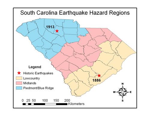
State of South Carolina showing the three earthquake regions. The state is also divided by counties and the 1886 earthquake is marked in the Lowcountry and the 1913 earthquake is marked in the piedmont.
Region 1: Lowcountry
This region is comprised of coastal counties and coastal plain areas with mainly very young (< 2 Myr) surficial sediments; this is the source of the Summerville/Middleton Place region 1886 earthquake as well as potentially the source of earthquakes near Georgetown and Bluffton (based on paleo-liquefaction); this region has a high liquefaction potential and there is a tsunami hazard along coastline.
Counties: Horry, Georgetown, Charleston, Berkeley, Dorchester, Beaufort, Jasper, Marion, Williamsburg, Colleton, Hampton, Florence.
Earthquake Risk: On the USGS (United States Geologic Survey) earthquake hazard map there is an ominous shade of red over the Charleston Tri-county area. Does this mean that a repeat of the 1886 earthquake is imminent? No, rather it indicates that unlike most of the east coast, Charleston does have a possibility based on experience of having a large (> 6.0 magnitude) earthquake. Talwani and Schaeffer (2001) used evidence from previous earthquakes to determine how often earthquakes like the 1886 earthquake have occurred in the Charleston/Coastal area. They determined that earthquakes in the Charleston area appear to occur about every 400-500 years and there is a possibility that large earthquakes may occur in Georgetown and Bluffton on ~2000 year cycles. Unfortunately, their data set is limited to only the last 6000 years because of changes in groundwater levels which affect the formation of earthquake features. Thus, it seems that it is unlikely that a large earthquake will occur soon in the Lowcountry, however, statistically there is a 1/400 chance that a large earthquake will occur each year. Smaller (<6.0 magnitude) earthquakes don’t tend to leave much evidence behind for scientists to find later, so it is unclear how often these occur in this area. Certainly, in the years since the 1886 earthquake, the Lowcountry has felt a number of quakes, some of which caused cracks in walls and chimneys to fall. These earthquakes generally do not cause major damage or injuries; however, it is important to know what to do during one to prevent injuries from happening. Because of the thick sediment cover and the predominant marshy/swampy nature of much of the Lowcountry, we can also expect that earthquakes that do occur will shake more than those in the Midlands and Piedmont/Blue Ridge.
Region 2: Midlands
This region is comprised of counties on the coastal plain with mainly older (< 2 Myr) surficial sediments; it includes the Fall Line as a potential earthquake source.
Counties: Dillon, Marlboro, Chesterfield, Darlington, Lee, Kershaw, Sumter, Clarendon, Richland, Calhoun, Orangeburg, Lexington, Aiken, Barnwell, Bamberg, Allendale.
Earthquake Risk: The Midland area is not known to have experienced any large earthquakes in the past, however, in recent years a number of smaller earthquakes have shaken residents in the counties near the Fall line. The Fall line of South Carolina represents a change in geology and also is the location of a very large fault system that stretches across the state. Until recently this fault line was considered relatively inactive, however, the recent earthquakes along this boundary indicate that it may be mildly active and accommodating stress generated a long way away at the Mid-Atlantic Ridge. So far the earthquakes in the Midlands have been small (magnitude 2-4) and caused minimal damage. The two earthquakes near Florence in the fall of 2006 caused minor damage to homes located on weaker soils and swampy land. Damage to homes is unlikely in small earthquakes; however, the thin cover of loose sediment in parts of the midlands and especially the swampy areas can increase the amplitude of the earthquake waves and increase the shaking felt. Dams in the Midlands have also been known to create small earthquakes due to excessive water pressure.
Region 3: Piedmont/Blue Ridge
This region comprises counties overlying almost entirely igneous/metamorphic basement rock with local river valley alluvium and weathered bedrock cover; this is the source of the 1913 Union County earthquake.
Counties: Oconee, Pickens, Anderson, Greenville, Spartanburg, Cherokee, Union, York, Chester, Laurens, Newberry, Fairfield, Lancaster, Abbeville, Greenwood, McCormick, Saluda, Edgefield.
Earthquake Risk: Generally, the Piedmont/Blue Ridge and Midlands sections of South Carolina are considered at low risk of major (magnitude 6+) earthquakes. However, in 1913 Union County South Carolina experienced an earthquake that by today’s standards would probably be measured as a 5.5 on the Richter scale. Not much is known about the cause of the Union County earthquake because of the lack of technology at the time, but at the present time, based on a lack of earthquake and fault motion in the area the earthquake risk is considered low. There is no evidence that another 5.5 or larger will occur in the near future, however, that does not rule out smaller earthquakes.
The Piedmont/Blue Ridge area is also susceptible to smaller earthquakes (magnitude 2-4) in other locations, especially near dams. The USC seismic stations have recorded numerous small earthquakes associated with dams in the Piedmont/Blue Ridge area and some smaller earthquakes distributed around the area. These small earthquakes not associated with dams may be associated with the uplift of the Appalachian mountains as is seen in other areas near the mountains.
Though small, earthquakes in the Piedmont/Blue Ridge are likely to be felt over large areas because of the relatively unbroken mass of rock they occur in. This allows earthquake waves to travel long distances before they become attenuated and are no longer felt. A good analogy is a bowl of jello, if you hit the side of a jello pan when the jello is smooth and unbroken the whole thing will jiggle; if the jello is all broken up and chopped up, it won’t shake as much. However, because most buildings are built on solid rock, earthquakes will also cause less damage than earthquakes in the Lowcountry because solid rock does not increase the amplitude of earthquake waves, whereas loose sediment can increase the shaking by increasing the amplitude of the waves.