How Do We Do It?
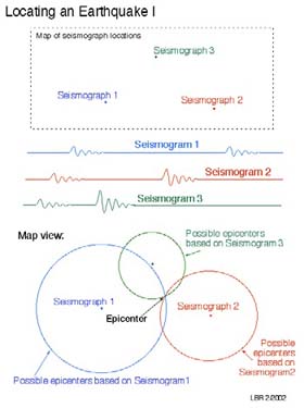
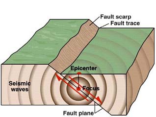
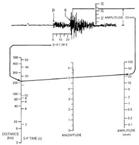
Locating an earthquake is usually done by reading the time that P- and S-waves arrive at a group (three or more) of seismograph stations. The greater the time between the P- and S-waves, the further the earthquake is from the seismograph. A travel time chart, showing how much time it takes for different seismic waves to reach a certain distance, is then used to estimate the distance from the earthquake to each seismograph. With at least three such distances it becomes possible to triangulate the location of the earthquake. The focus is the location on the fault where the actual breaking of the rock occurs, and the epicenter is the location on the surface of the earth directly above the focus.
The size of an earthquake, called its magnitude, is determined from the seismic waves created by the earthquake. The traditional way of determining magnitude is the Richter magnitude scale, which uses the distance between the earthquake and the seismograph and the amplitude of the largest recorded seismic wave.
The modern way of determining an earthquake’s size is called the moment magnitude (Mw). In this case, the total energy content of the seismic waves are determined by computer analysis (spectral analysis) and corrected for the distance between the earthquake and the seismograph. The moment magnitude scale gives a better measure of the true size of an earthquake than the original Richter magnitude scale, which underestimates the magnitude of the largest earthquakes, e.g., the 1960 Chile earthquake has a Richter magnitude of 8.5 but a moment magnitude of 9.5.
We can also estimate the size of pre-seismograph earthquakes by determining the area over which they were felt and comparing that to modern earthquakes for which we have a magnitude measurement. It is in this way we know the magnitude of the 1886 Charleston earthquake was between magnitude 6.9 and 7.3.
Although scientists have tried to find a way of predicting the time and location of a major earthquake before it strikes, so far no reliable earthquake prediction method has been found. Although some precursors, changes in the behavior of the Earth, have been recorded before some large earthquakes, these precursors do not reliably occur before enough large earthquakes to make them a useful means of earthquake prediction.
Some large earthquakes are preceded by foreshocks, one or more smaller earthquakes that occur at the same place as the coming, larger mainshock earthquake. Unfortunately, these earthquakes do not look different on a seismograph than any other earthquake. However, enough foreshock earthquakes occur in places such as California that the United States Geological Survey puts out a warning following a moderate-sized earthquake, telling the public to be aware that a larger earthquake may occur within a few days.
One type of earthquake seismologists can somewhat reliably predict is an aftershock. These are smaller earthquakes that almost always follow a large mainshock. The number and timing of aftershocks follow a predictable pattern, allowing them to be forecast with reasonable certainty. This is very useful during rescue and recovery operations following a large earthquake.
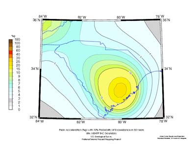
What seismologists can predict about earthquakes is how often they are expected to occur in a region and what strength of ground motion can be expected for an earthquake of a particular magnitude. This information is combined to produce seismic hazard maps. These maps are used in building codes, letting engineers and builders know how much additional strengthening against earthquake motion should be used when a new building is constructed.